RT. 10. BRITISH COLUMBIA TO TIA JUANA, MEXICO - MAPS

RT. 10. BRITISH COLUMBIA TO TIA JUANA, MEXICO
(Maps – Rt. 10) THE RED BOOK PICTORIAL TOURIST GUIDE AND SOUVENIR “A PICTURE EVERY MILE. ROUTE 10 – PACIFIC HIGHWAY. VANCOUVER, B.C. TO TIA JUANA, MEX.)
Reese, Jesse Lenhart (Pres.) and John Allan Wilson (Sec. - Tres.) General Advertising Company, Inc. Portland, OR: 1923. 260 pp. 1756 individual printed photo images, numerous photo- illustrated ads, 2 small photo images in round lozenge on title page, over 250 strip maps, local city maps and text illustrations.
First edition of this exceedingly scarce guidebook for automobile travel on the West Coast, from British Columbia, Canada through Oregon, Washington, California, and into Mexico, modeled on the popular Photo-Auto Guides. Rand McNally had purchased the sole publishing rights in 1910 for the Photo-Auto Guides from their inventor Gardner S. Chapin. He had developed this system because American roads at that time remained largely unpaved, and unmarked with no street signs; and
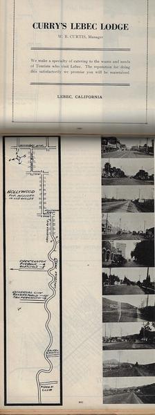
automobile enthusiasts up to that time largely depended on the vague instructions from locals to get from one place to another. The photos in this guide, with “a picture every mile,” offer an invaluable contemporary record of all the crossroads, garages, hotels, parking areas, towns, and cities that a 1920’s motorist would have seen driving the 1750 mile-plus route. This guide is of particular interest and value for including the strip maps paralleling the photos in 10 mile increments, but also the extensive
photos and tourist information for the locales the early motorist would visit. Unlike the Rand McNally photo guides, these photos are arranged like movie film strips keyed to the integral strip maps. These offer an invaluable contemporary record of all the crossroads, garages, hotels, parking areas, towns, and cities that an early traveler would have seen as he drove down the West Coast. The photos often include images of contemporary automobiles traveling on the roads, parked, as well as specific road conditions
noting whether the highways and streets are paved, concrete, cobblestone, or gravel. The General Advertising Company has included photos and instructions, along with local histories for visiting Bellingham, Seattle, Tacoma, Mt. Rainier, the Siskiyous, Yellowstone, The Columbia River Highway, Portland, Jacksonville County, OR, Pismo Beach, CA, Los Angeles, CA, and much more.
The ads for restaurants, garages, repair shops, automobile dealers, hotels, tourist spots, and more are
often nicely illustrated. By 1925 The General Advertising Co. had reconstituted as the Red Book
Publishing Co. in Seattle, Washington, which operated until 1927 under President and real estate salesman, Reese (b.1891), with Wilson (1868-1937) who would later form the Jupiter Sales Co.
No copies located in Worldcat; See: Paumgarten, GETTING THERE: THE SCIENCE OF DRIVING DIRECTIONS, New Yorker Magazine, April 24, 2006;
David Allen, Commercial Cartography, 1860-1920, Chapter 13; US Copyright Office, Catalogue of Copyright Entries 1923, Part I, N.S., V. 20 (1924), No. 26094
Limp red cloth, gilt lettering on front cover. Expected minor wear. Overall in vg cond.
